
 E-mail Alert
 RSS
RSS
Analysis on stitching overlap pixel threshold of one-orbit multi-strip agile remote sensing imaging
-
摘要:
针对敏捷成像中的多条带拼接成像模型,对条带图像的拼接重叠度进行仿真分析。建立多条带拼接成像的任务模型和几何退化模型,提出重叠区域宽度阈值的判别准则。针对星下点条带,分析不同场景类型遥感图像的重叠区域宽度阈值,探究了地面分辨率变化对重叠区域宽度阈值的影响。针对敏捷条带,分析了俯仰、横滚等敏捷特性对于重叠阈值的影响。仿真结果表明,在0.46 m地面分辨率下,6类场景类型重叠宽度阈值均在28 pixels以上,其中军港机场、海岛阈值较大,超过31 pixels。阈值统计符合正态分布的3σ原则,证明了阈值求解方式的可信度。星下点成像时地面分辨率变化对像面重叠像素阈值无太大影响,但对地面实际重叠宽度阈值影响较大。而敏捷条带成像时,卫星的俯仰和横滚将会增大条带的重叠宽度阈值,几何变形对阈值的影响超过星下点时地面分辨率的变化。通过对条带拼接重叠度的仿真分析,为敏捷卫星的高分辨率光学成像任务规划提供了有意义的参考。
 Abstract:
This paper shows some simulation analysis on stitching overlap threshold of strip images for multi-strip stitching model in agile remote sensing imaging. The mission model and geometric degradation model are proposed for multi-strip stitching imaging, and the criterion of overlap region width threshold is presented. Against the nadir strip, we analyze the overlap threshold of different scene types and explore the threshold variation affected by the changes of ground sample distance (GSD). For the agile strip, the effect of pitch angle and roll angle on overlap threshold is analyzed. The simulation result shows that, at 0.46-meter GSD value, the overlap threshold is more than 28 pixels for 6 scene types, and it is even beyond 31 pixels for the airport and island. The statistical characteristics of threshold perfect match the 3σ guidelines in normal distribution, which has proved the reliability of the solution of overlap threshold. In nadir imaging, GSD has little effect on the overlap pixel threshold at image plane, but has a great effect on overlap distance threshold at ground plane. In agile strip, with larger pitch angle and roll angle, the overlap threshold will increase significantly, which means that the geometric degradation is more powerful to the threshold than the GSD variation. By analyzing the stitching overlap threshold of the strips, we give a meaningful suggestion to the mission planning of high resolution remote sensing imaging by agile satellite.
-

This paper shows some simulation analysis on stitching overlap threshold of strip images for multi-strip stitching model in agile remote sensing imaging. To realize the high spatial resolution and high time resolution at the same time, agile satellites have been used more frequently. Besides the maneuverability of satellite attitude adjustment, the mission planning is the key to the efficiency of high resolution optical imaging. Thus, our purpose is to find the suitable stitching overlap width between two adjacent strips. Lower threshold will sacrifice the stitching quality of remote sensing image, while higher threshold will cause an inefficient imaging mission. The mission model and geometric degradation model are proposed for multi-strip stitching imaging, and the criterion of overlap region width threshold is presented. We use scale-invariant feature transform (SIFT) detector for image registration and random sample consensus (RANSAC) to eliminate the outliers. Besides the root-mean-square error (RMSE) of feature points in overlap region, the RMSE of four corner points and all pixel points of overlap region are considered. When all these three RMSE are less than 1 pixel, the overlap threshold is confirmed.
Against the nadir strip, we analyze the overlap threshold of different scene types and explore the threshold variation affected by the changes of ground sample distance (GSD). For the agile strip, the effect of pitch angle and roll angle on overlap threshold is analyzed. The simulation result shows that, at 0.46-meter GSD value, the overlap threshold is more than 28 pixels for 6 scene types, and it is even beyond 31 pixels for the airport and island. The statistical characteristics of threshold perfect match the 3σ guidelines in normal distribution, which has proved the reliability of the solution of overlap threshold. In nadir imaging, GSD has little effect on the overlap pixel threshold at image plane, but has a great effect on overlap distance threshold at ground plane. In agile strip, with larger pitch angle and roll angle, the overlap threshold will increase significantly, which means that the geometric degradation is more powerful to the threshold than the GSD variation. Compared with the roll angle, the pitch angle will bring greater impact on pixel threshold of overlap region. Specifically, when the equivalent pitch angle is beyond 40 degree, the pixel threshold grows significantly.
By analyzing the stitching overlap threshold of the strips in a variety of scene types and different remote sensing conditions in orbit, we give a meaningful suggestion to the mission planning of high resolution remote sensing imaging by agile satellite.
-

-
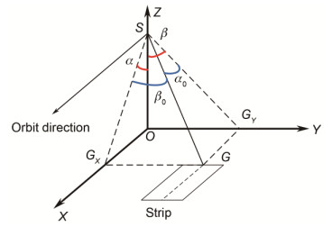
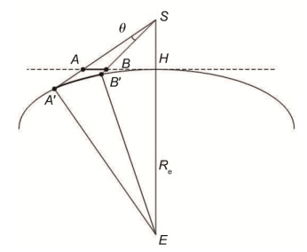
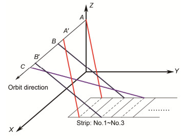
图 2 卫星姿态示意图.
Figure 2. Attitude of agile satelliteImaging model of one-orbit multi-strip stitching.
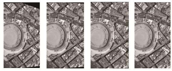
图 6 拼接效果. (a) 21像素. (b) 26像素. (c) 30像素. (b) 40像素.
Figure 6. Stitching result. (a) 21 pixels. (b) 26 pixels. (c) 30 pixels. (b) 40 pixels.
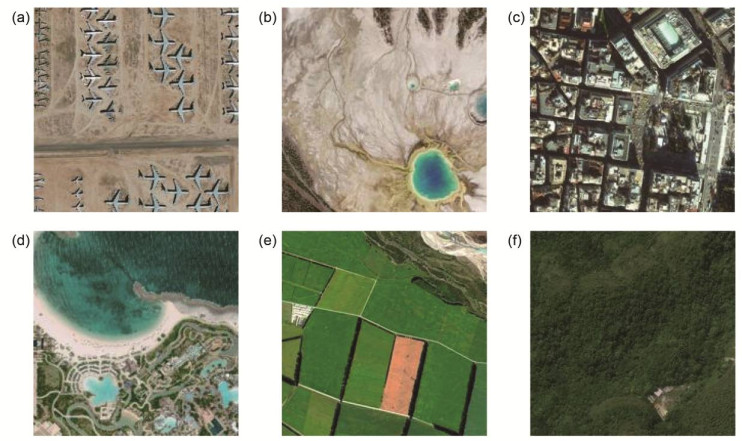
图 8 6类仿真场景样本示例. (a)机场和海港. (b)冰川和沙漠. (c)城市. (d)岛屿. (e)村庄. (f)森林.
Figure 8. Examples of 6 types of simulation source images. (a) Airport and naval port. (b) Glacier and desert. (c) City. (d) Island. (e) Village. (f) Forest.
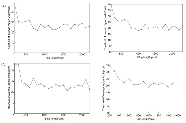
图 9 4种场景条带长度仿真. (a)机场. (b)城市. (c)岛屿. (d)村庄
Figure 9. Strip length simulation of 4 scene types. (a) Airport. (b) City. (c) Island. (d) Village.
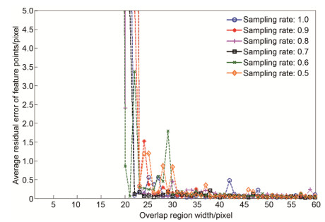
图 10 不同下采样率下的重叠区域内所有点的匹配残余RMSE.
Figure 10. RMSE of all points in overlap region at different sampling rates.
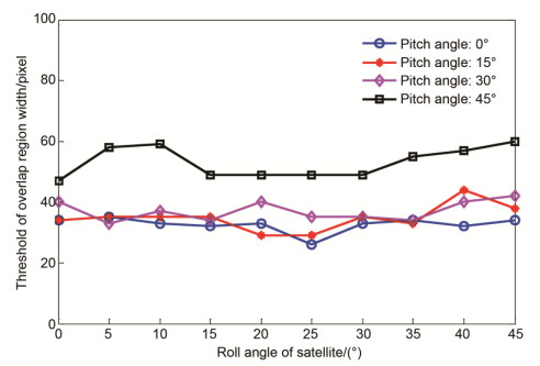
图 11 等效俯仰角为0°、15°、30°、45°时重叠宽度阈值随等效横滚角的变化关系.
Figure 11. Relation between overlap width threshold and roll angle at pitch angle of 0°, 15°, 30° and 45°.
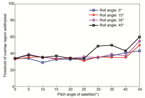
图 12 等效横滚角为0°、15°、30°、45°时重叠宽度阈值随等效俯仰角的变化关系.
Figure 12. Relation between overlap width threshold and pitch angle at roll angle of 0°, 15°, 30° and 45°.
表 1 线阵方向分辨率修正系数(部分采样点).
Table 1. Fix coefficient of DX (part of the sampling point)
Equivalent pitch
angle/(°)Equivalent roll angle/(°) 0 15 30 45 0 1.0000 1.0026 1.0123 1.0390 15 1.0080 1.0107 1.0209 1.0487 30 1.0386 1.0417 1.0534 1.0859 45 1.1268 1.1312 1.1479 1.1957  下载: 导出CSV
表 2 6种场景类型重叠区域宽度均值与标准差.
Table 2. Mean and standard deviation of overlap width threshold of 6 scene types.
Scene
typeAirport Desert City Island Village Forest Mean of
threshold
/pixels28.95 25.35 25.80 26.57 25.64 23.20 Standard
deviation
/pixels4.30 2.98 2.96 5.39 3.05 3.99
下载: 导出CSV
表 3 重叠阈值3σ验证.
Table 3. 3σ verification of overlap width threshold.
Scene type Airport Desert City Island Village Forest Normal distribution (μ-σ, μ+σ) /Probability 0.7000 0.6471 0.6863 0.6852 0.6970 0.6000 0.6827 (μ-2σ, (μ+2σ) /Probability 0.9500 0.9412 0.9804 0.9630 0.9545 1.0000 0.9544 (μ-3σ, μ+3σ) /Probability 1.0000 1.0000 0.9804 1.0000 1.0000 1.0000 0.9974 Number of images 20 17 51 54 66 10
下载: 导出CSV
表 4 6种场景统计重叠宽度阈值.
Table 4. Statistical overlap width threshold of 6 scene types.
Scene type Airport Desert City Island Village Forest Statically
threshold
/pixels33.25 28.33 28.76 31.96 28.68 27.19
下载: 导出CSV
表 5 重叠宽度阈值随采样率的变化关系.
Table 5. Relation between overlap width threshold and sampling rate.
Sampling rate 1 0.9 0.8 0.7 0.6 0.5 Threshold /pixels 22 25 23 22 23 31
下载: 导出CSV
-
[1] 张新伟, 戴君, 刘付强.敏捷遥感卫星工作模式研究[J].航天器工程, 2011, 20(4): 32-38. http://www.cqvip.com/QK/97505X/201104/38769096.html
Zhang Xinwei, Dai Jun, Liu Fuqiang. Research on working mode of remote sensing satellite with agile attitude control[J]. Spacecraft Engineering, 2011, 20(4): 32-38. http://www.cqvip.com/QK/97505X/201104/38769096.html
[2] 韩昌元.近代高分辨地球成像商业卫星[J].中国光学与应用光学, 2010, 3(3): 201-208. http://www.cqvip.com/QK/60129X/2010003/34449637.html
Han Changyuan. Recent earth imaging commercial satellites with high resolutions[J]. Chinese Journal of Optics and Applied Optics, 2010, 3(3): 201-208. http://www.cqvip.com/QK/60129X/2010003/34449637.html
[3] 葛玉君, 赵键, 杨芳.高分辨率光学遥感卫星平台技术综述[J].国际太空, 2013(5): 2-8. http://www.wanfangdata.com.cn/details/detail.do?_type=perio&id=gjtk201305001
Ge Yujun, Zhao Jian, Yang Fang. Review of high resolution optical remote sensing satellite[J]. Space International, 2013(5): 2-8. http://www.wanfangdata.com.cn/details/detail.do?_type=perio&id=gjtk201305001
[4] Jacobsen K. High resolution satellite imaging systems-an overview[J]. Photogrammetrie-Fernerkundung-Geoinformation, 2005, 6: 487-496. https://www.researchgate.net/publication/228676576_High_Resolution_Satellite_Imaging_Systems-an_Overview
[5] Poli D, Toutin T. Review of developments in geometric modelling for high resolution satellite pushbroom sensors[J]. The Photogrammetric Record, 2012, 27(137): 58-73. doi: 10.1111/phor.2012.27.issue-137
[6] Lemoine G, Bielski C M, Syryczynski J. Fast surface height determination using multi-angular WorldView-2 ortho ready urban scenes[J]. IEEE Journal of Selected Topics in Applied Earth Observations and Remote Sensing, 2012, 5(1): 80-88. doi: 10.1109/JSTARS.2011.2180366
[7] de Lussy F, Kubik P, Greslou D, et al. Pleiades-HR image system products and quality, pleiades-HR image system products and geometric accuracy[C]//Proceedings International Society for Photogrammetry and Remote Sensing International Conference, Hannover, 2005: 17-20.
[8] 程宇峰, 金淑英, 王密, 等.一种光学遥感卫星多相机成像系统的高精度影像拼接方法[J].光学学报, 2017, 37(8): 0828003. http://www.opticsjournal.net/Articles/Abstract?aid=OJ1708020002049EbHdK
Cheng Yufeng, Jin Shuying, Wang Mi, et al. An high accuracy image mosaicking approach of optical remote sensing satellite for multi-camera system[J]. Acta Optica Sinica, 2017, 37(8): 0828003. http://www.opticsjournal.net/Articles/Abstract?aid=OJ1708020002049EbHdK
[9] 余婧, 喜进军, 于龙江, 等.敏捷卫星同轨多条带拼幅成像模式研究[J].航天器工程, 2015, 24(2): 27-34. http://kns.cnki.net/KCMS/detail/detail.aspx?filename=htgc201502005&dbname=CJFD&dbcode=CJFQ
Yu Jing, Xi Jinjun, Yu Longjiang, et al. Study of one-orbit multi-stripes splicing imaging for agile satellite[J]. Spacecraft Engineering, 2015, 24(2): 27-34. http://kns.cnki.net/KCMS/detail/detail.aspx?filename=htgc201502005&dbname=CJFD&dbcode=CJFQ
[10] Wang Yamin, Xu Wei, Jin Guang, et al. An attitude algorithm based on the band seamless splicing imaging for agile satel-lite[J]. Optoelectronics Letters, 2017, 13(5): 376-380. doi: 10.1007/s11801-017-7058-x
[11] Sun Tao, Long Hui, Liu Baocheng, et al. Application of side-oblique image-motion blur correction to Kuaizhou-1 agile optical images[J]. Optics Express, 2016, 24(6): 6665-6679. doi: 10.1364/OE.24.006665
[12] Barazzetti L, Roncoroni F, Brumana R, et al. Georeferencing accuracy analysis of a single worldview-3 image collected over milan[M]//Halounova L, šafář V, Toth C K, et al. XXIII ISPRS Congress, Commission I. 2016: 429-434.
[13] 葛芸, 江顺亮, 叶发茂, 等.视觉词袋和Gabor纹理融合的遥感图像检索[J].光电工程, 2016, 43(2): 76-81, 88. http://www.wanfangdata.com.cn/details/detail.do?_type=perio&id=gdgc201602013
Ge Yun, Jiang Shunliang, Ye Famao, et al. Remote sensing image retrieval based on the fusion of BoVW and Gabor tex-ture[J]. Opto-Electronic Engineering, 2016, 43(2): 76-81, 88. http://www.wanfangdata.com.cn/details/detail.do?_type=perio&id=gdgc201602013
[14] Lowe D G. Distinctive image features from scale-invariant keypoints[J]. International Journal of Computer Vision, 2004, 60(2): 91-110. doi: 10.1023/B:VISI.0000029664.99615.94
[15] Fischler M A, Bolles R C. Random sample consensus: a paradigm for model fitting with applications to image analysis and automated cartography[J]. Communications of the ACM, 1981, 24(6): 381-395. doi: 10.1145/358669.358692
-

 点击扫一扫
点击扫一扫
图(12)
表(5)
计量
- 文章访问数: 6828
- PDF下载数: 3158
- 施引文献: 0


